Overview
Teaching: 20 min Exercises: 0 minQuestions
How do I quickly share a large amount of geospatial data between my collaborators?
How can I leverage available cloud tools to enhance data sharing?
Objectives
Understand how cloud computing can help you disseminate your data quickly
Use Amazon Web Services to spin up a quick instance of an open source server for geospatial data (Geoserver)
Understand potential use case
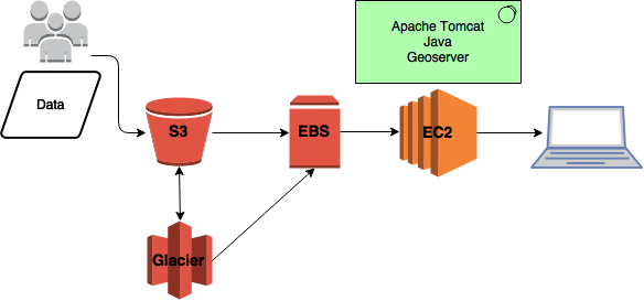
Using the AWS s3 (Simple Storage Solution) bucket
- Allows a bunch of people to dump in their data instead of giving everyone access to your virtual machine
- You can set access permissions
- s3 serves as backup - you can also move really old data that you don’t need rapid access to to Glacier storage
- Use sync to transfer data from s3 to EBS
- Use s3 Lifecycle rules to move data that’s older than X date to glacier
Since your data is stored on S3 there is no need to to re-download data when you want to do analysis on an AWS instance. You can use the S3 API to call your data.
Why use Geoserver?
- Web map and web feature service
- Open source :-)
Set up Geoserver
- install Apache Tomcat (for stability, use Tomcat7)
- install Geoserver
- Install OpenGeoSuite from Boundless! - comes bundled with PostGIS and bunch of other tools.
Costing
- s3 bucket - 3TB ~ $1100/year
- Glacier - 5TB ~ $450/year
- ec2 Instance (m4.large) with 2TB EBS ~ $3400/year
- Total cost ~ $5000/year
AMIs
The good thing about setting your server up on the cloud is that you can easily create machine images! A machine image is a replica of your root applications and snapshots of your volumes (i.e. data). Caveat: You need to set up snapshots and there’s a small associated cost. You can easily share your Geoserver setup with collaborators.
And if you’re lazy…
I have an AMI created with Geoserver installed - I’ll share.
Ways to save $$$
- You may not actually need 8TB of storage space! Don’t be a data hog. s3 buckets can easily be plugged in anywhere!
- Turn off your EC2 machine if you’re not using it!
Key Points
AWS s3, EC2 and EBS
Creating AMIs